On Saturday, July 9th, I walked up to San Luis Pass, and then a bit east on the Continental Divide and Colorado Trail - hereafter CDT/CT. While in the pass, I wondered what the trail looked like to the west, so I decided to find out. I left the RV park at 0622. We had a lot of rain last night, and there were heavy clouds hanging low over the valley. I could see the sun about to peek over the mountains to the east, and figured there was a good chance that where I was going was above the clouds. And I got above the clouds at about 10,500 feet.
I got up to the mine a little before 7 A.M. The road up to where I wanted to park was closed through the mine - it had been open on Saturday. They are doing some work on that mine with heavy equipment, and Tom Owens, one of the other avid hikers who lives in the park, heard they are doing some exploratory work. Given the current price of gold and silver, that's not surprising.
There is a bypass around the mine - a narrow, steep, and rocky four-wheel drive road. I locked the hubs, and crawled up the road. If it has been wet, rocks are not bad, as they provide better traction than bare dirt, as long as they are not too big, and they weren't. The secret to traversing a 4WD road without breaking anything is to go slowly. I did - I could have walked that stretch of road faster. But, then, I'd have been walking... I had no trouble getting to the parking place, around 0721.
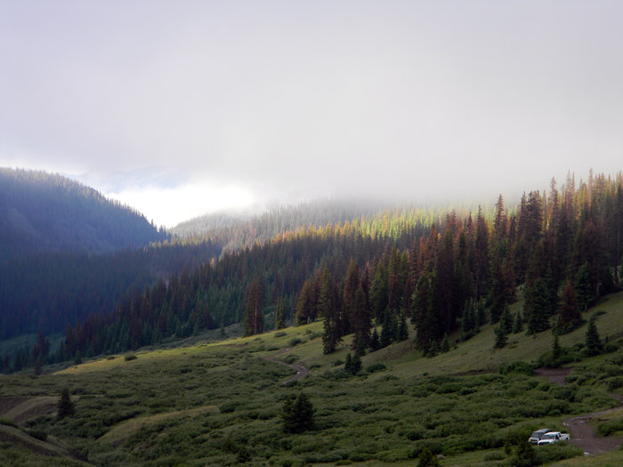
This is the parking place, as seen from the trail above it. The white dot in the lower right corner of the picture is my truck, parked next to a Jeep with Nebraska plates. Behind it, down the valley, under the clouds somewhere, is Creede. That is a pretty scenic parking place, I think.
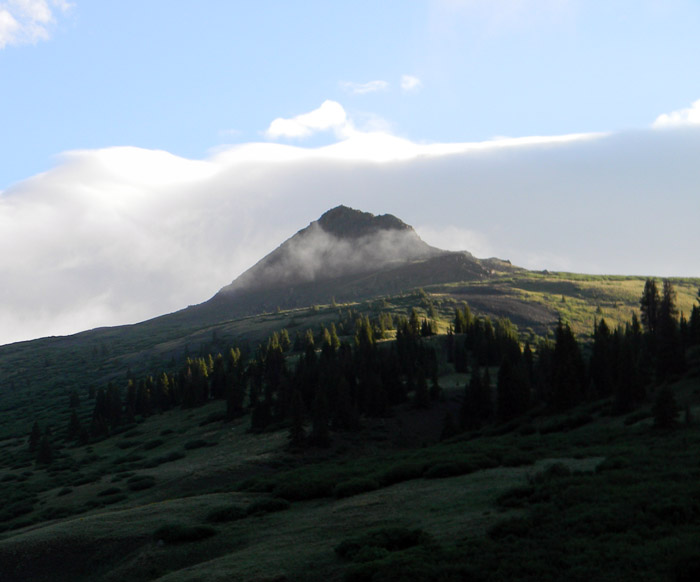
As I walked up the trail from the truck, the sun was just lighting up the higher peaks. The one below is pretty, and is not named on any map I have.
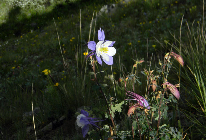
A biologist for the Forest Service told me that it is the length of the day which triggers changes in vegetation, whether flowers coming out, or leaves changing colors. Whether it's that or the rain we've been getting, or both, the flowers are out in incredible variety and profusion. Below is a Columbine.
I walked up to the trail junction, and headed west on the CDT/CT. The trail climbs a bit more than 1300 feet in the next 1.8 miles, which is an average grade of about 14 percent. If you try walking on a treadmill at that grade, it'll give you an idea of what that was like. I just took smaller steps, and kept chugging. Near the top, I took the picture below of the Cascade creek drainage, which runs to the north of the trail junction.
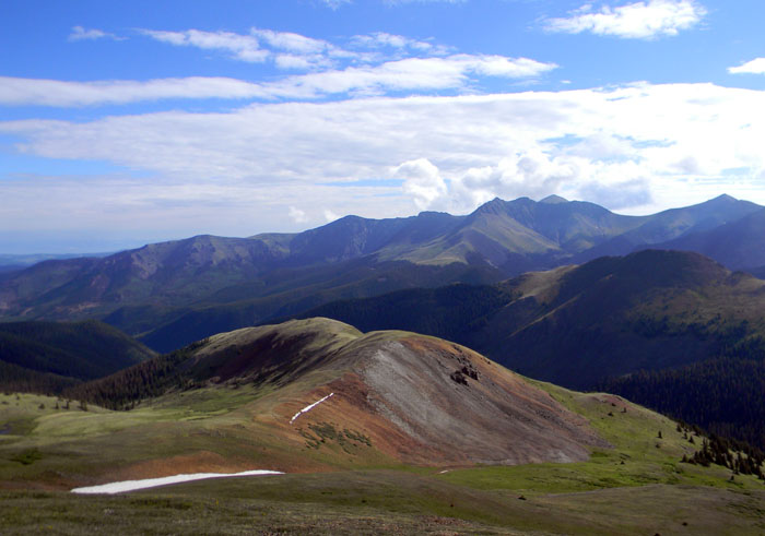
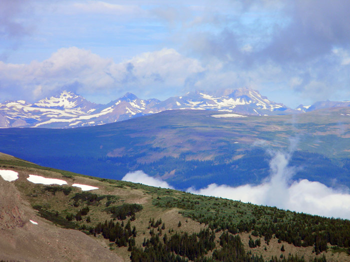
I got to the top at 12,852 feet at about 0904. The views were lovely in every direction. The trail descended to the west from that point, and I didn't want to walk any farther that way, so I just wandered off to the north, following a contour line on the ridge line, and eventually a very faint game trail, probably used by elk and/or mountain sheep. The picture below is off to the northwest. The right-most peak in that picture is, I believe, Uncompahgre Peak, although it's a bit obscured by clouds, and, if so, it's about 27 miles away.
I walked back to the trail, and found a spot a little lower down somewhat out of the wind. It was about 45 degrees, and the wind was a bit chilly. I drank some water while waiting for the GPS and SPOT to transmit my location to Facebook. Yeah, I'm a geek. Once a geek, always a geek, I guess - and I've been a geek for a long time.
While I was doing that, a guy walked up the trail from the west, and we introduced ourselves. Patrick, and Tim, who came along a few minutes later, are through-hiking the Colorado Trail, which runs from Durango to Denver, and follows the CDT for some of that length. Patrick asked if there was cell service in the vicinity. I told him I didn't think so. He tried his phone, and got one bar, but was unable to get a call through. I offered to make phone calls for him and Tim when I got back down. Both gave me messages, and Patrick a list of three things he wanted his wife to bring him at a trailhead up by Gunnison.
Another eastbound hiker caught up with us while we were chatting, and a westbound hiker passed by while we were descending back down to San Luis Pass. The trail is busy this time of the year, I guess. It's nice to see people out hiking the long trails - the Pacific Crest Trail, the Continental Divide Trail, and the Appalachian Trail are known as The Big Three. The AT gets the most traffic, with hundreds of through-hikers, but the PCT and CDT are more difficult, both from an altitude and trail difficulty standpoint, as well as logistically, and get less traffic.
After bidding them a good trip, I turned down the West Willow Creek trail, and got back to the truck right at 1100. It took me about a half-hour to traverse the 4WD road again, and another half-hour to get back to town after stopping to make calls for Patrick and Tim. Tim's wife said he had just turned 60 - he doesn't look it - and was spending 4 weeks on the trail as a birthday present. Nice present.
Another good day for me. The hike was about 6 miles, with about 3500 feet of elevation gain or loss.
I am blessed to have the ability and the opportunity to hike these mountains - and I turn 65 tomorrow.
All Rights Reserved