by Linden B. (Lindy) Sisk
Last Update 20120302 - Steripen Status Update
I am very conscious of pack weight, the result of having carried loads of 50 pounds or more in the mountains when I started backpacking decades ago, in an era when modern fabrics and insulating material were not available. In 1999, carrying more than 50 pounds up this trail in Mount Robson Provincial Park in Canada, at the age of 53, I decided that was madness. When I got back from that trip, I found Ray Jardine's book Beyond Backpacking, and I have not carried a load which exceeded 30 pounds since - including food and water, although I rarely hike in areas which require carrying more than two liters of water.
My base solo pack load for a trip involving one or more nights on the trail, in conditions where the temperature will not get much below freezing, excluding food, water, and the camera and electronic gear carried in a waist pack, is now around 16 pounds. For this trip, where three of us were sharing some basic gear like tents and cooking gear, my pack weight including food for six days, but not water, was around 21 pounds.
Lighter is better.
For years I have used a Go-Lite Gust Pack, which carried all that I needed, and weighed 12.5 ounces. It's essentially an unstructured sack, but with huge outside mesh pockets which are highly utilitarian. For this trip to Patagonia, I decided I needed a new pack, as that one is a little worn — and found that the Gust is no longer available. Rats!
I like Go-Lite equipment, so I ordered the lightest pack of appropriate capacity they make, the Jam. Unfortunately it weighs a lot more than the gust, at 30 ounces. It has a large exterior pocket on the back, two water-bottle pockets, and a waist belt. The waist belt, which the Gust does not have, turned out to be an advantage, as it kept the pack from shifting on my back when clambering up rocky, wet trails and crossing streams. It worked, and will now be my primary for backpacking.
Considering the conditions we might expect to encounter, I decided that my North Face Cat's Meow 20° bag was too heavy. I ordered a Mountain Hardwear Ultralamina 32° bag, which weighs 33 ounces including the stuff sack, a savings of 20 ounces over the Cat's Meow. It's filled with what the manufacturer describes as Thermic Micro insulation , light, compressible, and which does not absorb water. Having been burned by wet down bags, which lose most of their insulating properties in the presence of moisture, I have vowed never to carry another down bag. I was never cold in the Ultralamina on this trip, and will carry it in the Rocky Mountains during the summers. It does not have a full-length zipper, which might bother some in warmer conditions, but I did not find it a problem.
This bag is no longer listed on the manufacturer's web site - but similar bags using the same insulation are.
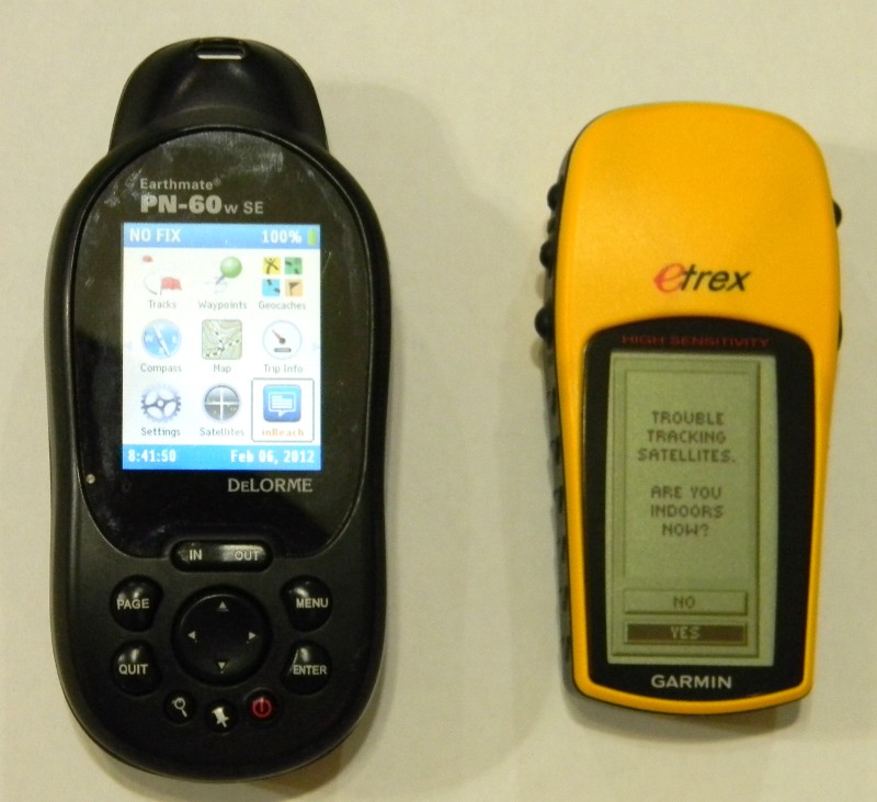
For this hike, I decided to carry two GPS receivers — a DeLorme PN60W, shown on the left, and a Garmin Etrex.
The DeLorme PN60W is my primary GPS receiver. It can be bundled with DeLorme TopoUSA software, which runs under Windows, and contains topographic maps of the entire United States, Canada, and Mexico. Selections of the maps can be downloaded into the GPS - I have most of the western United States loaded on a single 8 GB SD card. In addition, a map subscription which costs about $30 per year allows unlimited downloads of USGS maps, NOAA marine charts, and satellite photos, all of which can be displayed on the PC and on the GPS.
The GPS has many useful features, including the ability to generate a track of a route being hiked. That track can be used to retrace back to a selected point, and, once saved, it can be used to profile a hike on the PC. The track, which contains position data, including elevation, as well as speed and direction, stored about every 3 seconds, can be used by the TopoUSA to calculate elevation gain and loss, trail angle, and many ofther things. For details, see the manufacturer's web site.
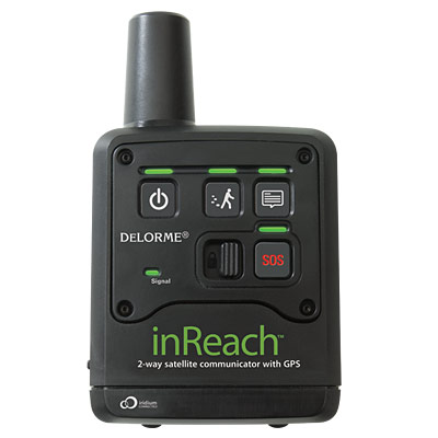
That receiver has two additional capabilities which make it an obvious choice — the ability to provide a Bluetooth interface to a SPOT transmitter, or a DeLorme inReach two-way satellite transceiver, which has the ability to transmit and receive SMS text messages and email messages anywhere on the planet, described below.
For this hike, I decided to carry an additional receiver, a Garmin Etrex. I am the Chairman of the Department of Redundancy Department — and the Garmin has one of the hottest receivers around, which finds its position faster than anything else I've used. It's a simple device, and, I suspect, less subject to electronic maladies.
One of the potential problem with this hike was a lack of good maps with topographic data and/or position coordinate data. Once I found the area we would be hiking in, I downloaded Google Earth maps of the area, overlaid them with a 1-kilometer Univeral Transverse Mercator (UTM) grid, and printed them. Because the Google photos of the primary area of concern were mostly covered with snow when the photos were taken, that did not turn out to be a useful thing to do — but I also used Google earth to determine UTM waypoints of many features in the area, which did.
The primary problem with this hike, as described in the trip report, was not knowing where we were, or where we wanted to get to, but how to get there, i.e., route finding. The GPS was only occasionally useful for the that — but the ability to retrace a route might have been.
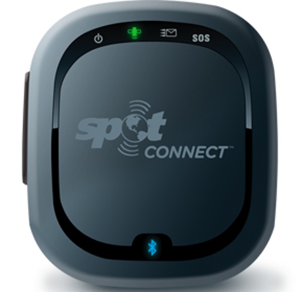
The DeLorme GPS has the ability to transmit messages, including Facebook, SMS, email, and emergency requests, through a SPOT transmitter. This page outlines the ability of the SPOT transmitter to do that using a cell phone - but the DeLorme GPS includes that ability as well, so there's no need to carry a cell phone into the backcountry solely for that reason.
I used that ability to ask Alex MacDonald to bring us cold beer to the exit trailhead of our Continental Divide hike in July of 2011. However, the SPOT is simply a transmitter, unlike the DeLorme inReach transceiver described below, so there is no way to know if messages are successfully transmitted and received. Alex did bring the beer, though...
I carried the SPOT transmitter on this trip. However, the superior capabilities of the inReach transceiver became so obvious that despite the greater cost of using the inReach, I did not use the SPOT. Tristan MacDonald did use his SPOT to generate position reports for our family and friends, so I felt no need to do so.
In 2011, DeLorme announced and then shipped the inReach, a two-way satellite transceiver which uses the Iridium satellite constellation. One can interface to the inReach using either the DeLorme PN60W or an Android cell phone. Messages can either be SMS text or email. There are several subscription plans — I have the most basic, about $10 U.S. per month, which includes 10 messages per month, with an additional cost of $1.95 per additional message. If you are going to be using the inReach to generate status messages for very many people, it makes economical sense to send each message to only one person, and ask them to relay it to additional recipients, as each separate recipient counts as a separate message.
One superiority of the inReach over the SPOT, beside the two-way messaging, is that one can tell immediately by watching the indicator lights on the transceiver if a message has been successfully transmitted through the inReach, a capability which doesn't exist in the SPOT. The SPOT transmits each message three times "in the blind", i.e., with no knowledge of which, if any, of the transmissions were successful, which can take up to 20 minutes, and that time period can be problematic.
In addition, with a SPOT, one must log in to the SPOT web site and predefine the data for each potential recipient, which must then by synced to the DeLorme GPS hooked to the PC via USB cable. If you're in a location with no PC or Internet access, you're unable to do that. With the inReach, addresses can be added on the fly for anyone you have information for. I used that ability to add Jeremy, our local contact in Bariloche for this hike. When conditions caused us to have to spend an extra day on the trail, I was able to notify Jeremy and ask him to notify our hotel, which potentially stopped them from generating a search request when we failed to appear on our scheduled date.
That kind of capability completely justifies to me the additional cost of inReach traffic, not to mention being able to conduct two-way traffic with emergency authorities. With batteries, it weighs 8 ounces.
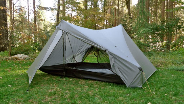
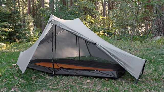
Tents
We carried two tents on this hike, a 2-person and a 1-person. Both are Tarptents, made by Henry Shire, and use trekking poles for suspension. The one on the left, the 1-person, is called the Notch, and weighs only 26 ounces — which is 6 ounces less than the bivy sack I sometimes carry. Complete specifications are on the web site. The 2-person model on the right is called Stratospire 2, and weighs 40 ounces. Both were purchased new for this trip, so we don't have a lot of information about durability.
They are coated single-wall tents, so they need to be pitched high enough for ventilation in cooler weather to minimize condensation. Despite a night of continuous rain, neither leaked. We camped in sheltered locations, yet we got high winds on the 4th night. Both stood up to the wind fine, though we did get some dirt blown under the fly on the 2-person tent. I would not hesitate to use them again in reasonably sheltered locations, and plan to purchase a Notch for my own use. In unsheltered spots in the mountains, I'd want something a little sturdier, but when I might have to camp in such a place, I typically carry a bivy sack and a small silicon-coated tarp in the event I must camp in a high wind.
We didn't manage to get either up in the two minutes the maker claims is possible, but we probably just need some more practice. The advantage of these is their light weight, which of course appeals to me, especially since I'll be hiking using trekking poles. They are nicely designed and carefully built, with obvious attention to detail.
Clothing
I hiked in 5.11 Tactical pants of polyester and cotton ripstop, with double knees and seat. They are heavy, but pretty much indestructible. The 5.11 brand originated with climber Royal Robbins, and when the brand became popular with military and law enforcement personnel, he sold it off. Aside from the cotton in those pants, I don't wear cotton when hiking in high altitudes and cold conditions. All of my other clothing, including underwear, is synthetic except for Merino wool socks. In cold and wet conditions, cotton clothing can kill you.
My lightweight rain jacket was useless on this trip. In heavy wind and rain, it allowed me to get completely soaked, so I'll be shopping for a replacement. This expedition quality Arc'teryx jacket is a prime candidate, although my inner Scottish accountant is bitching about the cost, which to me is justified by the incredibly light 19-ounce weight. I'll feed him some single-malt Scotch to shut him up...
Both Tristan and John had lightweight down "puff" jackets. I will be shopping for one of those, too, primarily for wear around camp, as they are light and stuff small.
Trekking Poles
As I mentioned in the trip report text, I resisted the use of trekking poles. No longer. They worked to save my skin on several occasions and perhaps my life on this trip. Tristan, fortunately, loaned me a new set of his to try — and he won't get them back. They're mine, and I'm mailing him a check for the cost. I don't know enough about the various brands and models of these to recommend specifics, but the ones I have work. I'm sure others do, too.
They also have the advantage of being used to support the tents we used.
Steripen
Tristan and I both carried Steripen ultraviolet-light water treatment devices on this hike. We both carried the same ones on our Continental Divide hike without problems. On this trip, both ceased working, mine on the evening of the fourth day, and his at midday of the fifth. While the models are slightly different, both failed in the same fashion — indicating immediately on activation that they weren't working. The problem was not batteries, as we immediately replaced the batteries with new ones. Nor was it the type of batteries — the same type was used throughout both trips, manufactured by perhaps the most prominent CR123 battery provider, purchased directly from them. What's puzzling is that now both appear to be working normally. Whether it was a problem with temperature, moisture in the water sensors, or what, I have no way of ascertaining.
The failure is disturbing. It was not serious, as we were boiling the water we used for both breakfast and dinner, and I had a bottle of Potable Aqua tablets to treat drinking water, but when one relies on expensive technology for something as vital, literally, as safe drinking water, one may reasonably expect it to work reliably. It did not. I will continue to carry and use mine - but I will always have the tablets as a backup.
Steripen Update: Tristan returned his Steripen to the factory. They sent him a new one. The note with the new one indicated a circuit board failure, and reminded him that they are water resistant, not water proof, and cautioned him not to immerse it in water much above the lamp. Mine now functions normally, so I will continue to carry it — along with purification tables as a backup.
Food
What we carried for breakfast was oatmeal, coffee, and a Clif bar. We carried a protein bar as a snack, as well as delicious trail mix prepared by Tristan with several kinds of nuts, dried fruit, and M&Ms. Lunch was instant soup supplemented sometimes by Ramen noodles. Dinner was two freeze-dried dinners of various kinds shared by the three of us, supplemented by couscous or Ramen noodles. In addition, for Happy Hour, we each carried some kind of adult beverage. I carried 3/4 of a liter of single-malt Scotch. If one assumes about 100 calories per ounce, the four ounces per day were a useful caloric supplement, though, of course, that was not the primary purpose...
I was never extremely hungry during the hike, though despite all of our indulgence in delicious local food, I did manage to lose about 3 pounds in the course of the hike. Tristan has described backpacking, accurately, as "slow starvation", as it's problematic to carry enough calories.
Miscellaneous Gear Notes
We carried nesting pots of about 1.5 liters and 2 liters for cooking. We carried two identical Mountain Safety Research Pocket Rocket butane/propane stoves, in case we wanted two pots going simultaneously as well as for redundancy. The fuel for those is widely available, which was a factor for us, as you can't transport it on passenger aircraft. We had no problem finding it in Bariloche.
I wore a Casio Pathfinder digital watch, which has an electronic compass, altimeter, and atmospheric pressure sensor. I used it mostly to check altitude without having to consult a GPS.
I used exclusively Energizer Ultimate Lithium batteries in my camera, GPS receivers, inReach, and headlamp. They last several times longer than conventional alkaline batteries, and are lighter to boot. They are more expensive, but the extended use lifetime and the lighter weight make them a bargain in the mountains.
All Rights Reserved

Pack
Sleeping Bag
 GPS Receivers
 SPOT Transmitter
 inReach Satellite Transceiver
© 2012 by Linden B. (Lindy) Sisk